Geological background
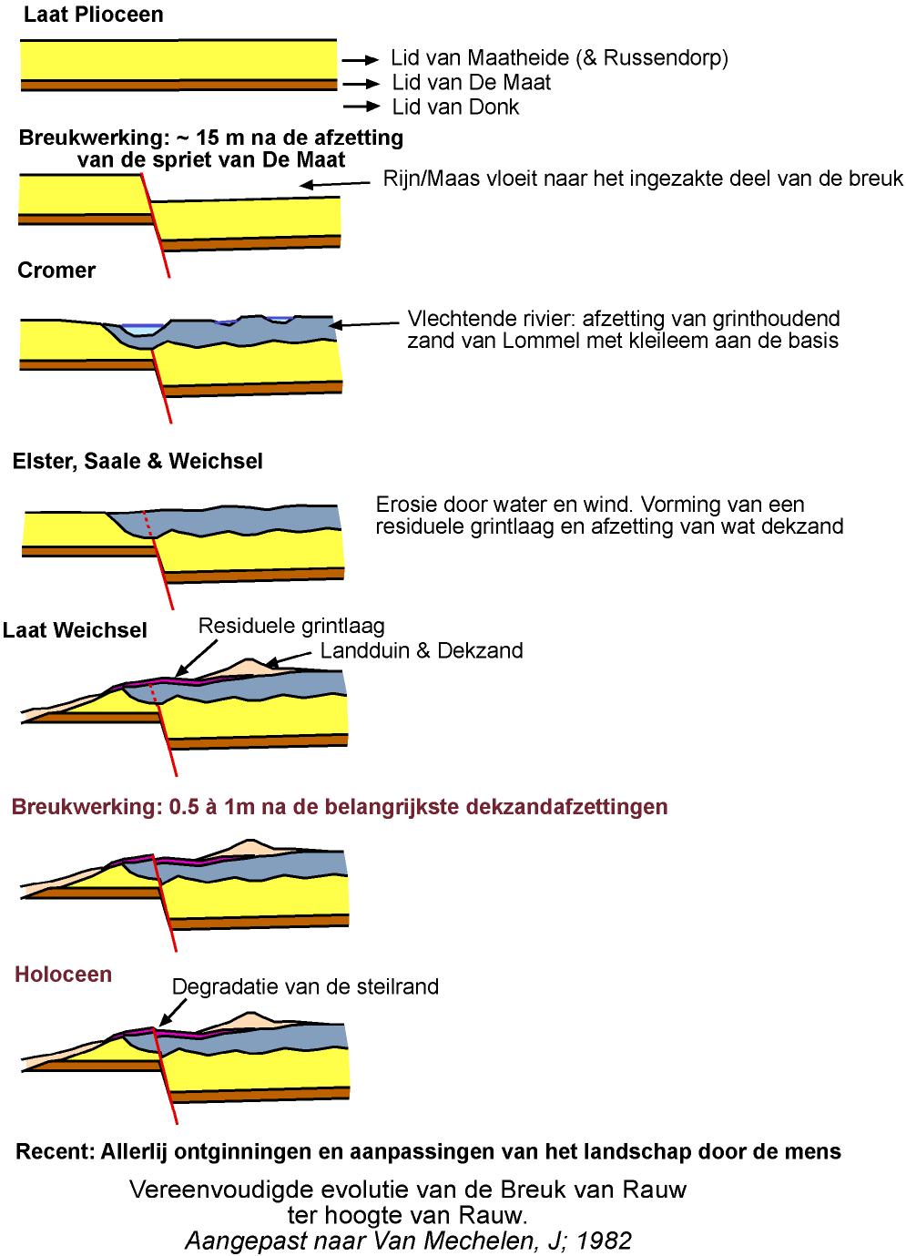
In this region the extremely pure quarts sands of Mol (Pliocene) are dug up and exported all over the world by S.C.R.-Sibelco. In one of the quarries Gullentops, Huyghebaert, Wittewrongel & Dricot (1974) noticed that the De Maat peat in the Mol sands has a 15 m displacement along the Rauw fault. The peat layer has the same thickness at both sides of the fault.
|
|
The marine late Pliocene Poederlee sands wedge out north of our study area and are probably not present. Praetiglian Braschaat sands lie discordantly over the Mol and Poederlee sands in the north of the study area. Due to tectonic activity of the Roer graben faults, including the Rauw (and possibly Poppel) fault, the Rhine-Maas delta displaced westward and during Cromer the Lommel sands deposited east of (possibly above) the Rauw fault. A new tectonic pulse made the Maas break through its interfluvium, massive deposition of the Zutendaal gravels southeast of our study area caused the river to move eastward again. During the following Elster, Saale and Weichsel glacials mainly erosion by water and wind took place. Differential erosion of the Mol sands to the west and the Lommel sands (containing some gravel) to the east of the Rauw fault made the relief to inverse. The actual relief is opposite to what one would expect for the Rauw fault. This indicates that the differential erosion goes faster than the tectonic movement or, as some believe, that inverse tectonics took place along the Rauw fault.
Just to the north and the south of our study area late Quaternary and even Holocene fault movements are reported (Matthijs, 1999 & Vandenberghe, J., 1982 & 1999) on the prolongations of the Poppel and Rauw faults.
No historical or instrumental earthquakes are reported for this area during the 100 years of seismograph measurements and the 700 years of written historical sources. But the observation period is far too short in comparison to the seismic cycle of the faults estimated at several ten or even hundred thousand years. The only way to extend our observation in time is to search for the evidences of earthquakes in the recent geologic layers and in the landscape. However, only large earthquakes are able to break through the whole seismogenic zone up to the surface but these are also the most relevant in a safety analysis.