

Brexit 1.0: scientists find evidence of Britain’s original separation from Europe
Researchers of the Royal Observatory of Belgium and of the Ghent University, in collaboration with English and French colleagues, have found evidence of how ancient Britain separated from Europe, nearly 450,000 years ago. They reported it on 4 April 2017 in Nature Communications. The process, which occurred in two stages, was triggered by the spillover from a proglacial lake followed by catastrophic flooding. Following Sanjeev Gupta from Imperial College London, “without this dramatic breaching Britain would still be a part of Europe. This is Brexit 1.0 – the Brexit nobody voted for.”
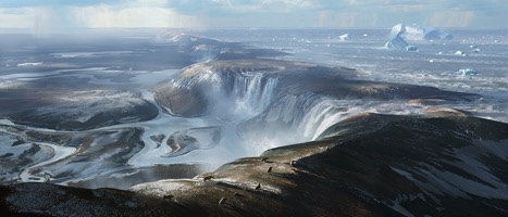
Artist’s view of the land bridge connecting England and France. This is an illustration of how France and England could have looked like before the formation of the Dover Strait. The foreground is where the Calais harbor is today and England is in the background. Water from the proglacial lake, in what later will become the Southern part of the North Sea, spills over the land bridge through big waterfalls. This is the beginning of the separation between England and the European continent.
The Strait of Dover 500 000 years ago
Nearly 500,000 years ago, when Earth was in a warmer period between two ice ages, England and Europe were connected via a land bridge. Remains of this land bridge are still visible today in England (the cliffs of Dover) and in France (Cap Blanc Nez).
When Earth was in the grip of an ice age, nearly 450,000 years ago, the sealevel was 100 meter lower than today and an ice cap stretched right across the North Sea, from Britain to Scandinavia. The low sea levels meant that the entire English Channel was dry land, a frozen tundra landscape, crisscrossed by small rivers.
At the end of this ice age, water melted from the ice cap and water brought by rivers of England and Europe could no more flow to the North because of the ice cap. Since it was also blocked to the South by the dam between England and Europe, a big proglacial lake – a type of lake formed in front of an ice sheet – formed in the Southern part of the North Sea. This lake was first hypothesised by scientists more than 100 years ago.
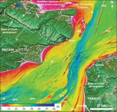
Bathymetric map of the Dover Strait, on which one can see a prominent eroded valley in the central part of the Strait. Notice that there are still faint marks of the land bridge (Credit: Imperial College London).
A process in two stages
The authors from the present study show how this lake at first spilled over, generating huge waterfalls that caused deep plunge pools, which could be observed in the Channel bathymetry and in seismic cross-sections.
Those plunge pools were called the Fosse Dangeard. They are up to several kilometres in diameter and around 100 metres deep. Around seven plunge pools run in a line from the ports of Calais to Dover.
In a second stage, continued spilling progressively eroded and weakened the land bridge, and finally triggered its failure by a catastrophic breach, allowing huge quantities of water to flow in the Channel. This resulted in a new valley system, the Lobourg Channel, that was carved by megafloods that crossed the Dover Strait from the North Sea.
The Belgian contribution
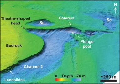
3-D perspective view of a cataract in the eroded valley in the central part of the Dover Strait. One can notice small erosion cavities created at the basement of the cataract. These data indicate that the erosion occurred through strong currents. (Credit: Imperial College London).
Researchers from the service “Seismology and Gravimetry” from the Royal Observatory of Belgium have contributed to the study by performing two missions of geophysical measurements in the Dover Strait, in collaboration with the Ghent University. Those measurements were performed onboard the oceanographic ship Belgica. The purpose of this campaign was to identify and evaluate the seismic activity of the fault zone responsible for the historic earthquake of magnitude 6.0 that occurred in 1580 in this region.
Based on the collected data, this fault zone was clearly identified. However, to evaluate its relative displacements and its activity, one needs to know the recent environmental history of the Dover Strait. As the newly collected data complemented those collected by the English and French researcher teams, it was possible to put them together in a common dataset,which resulted in new insights in the catastrophic events leading to the opening of the Dover Strait.
Dr. Thierry Camelbeeck and Dr. Kris Vanneste, both researchers from the Royal Observatory of Belgium and co-authors of the article, say: “This is a very beautiful example that shows how scientific research can lead to unexpected results. It also shows how collaboration across several science disciplines can lead to new insights.”
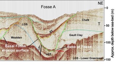
Geophysical data represented by a cross-section through the subsurface of the Dover Strait. This section shows a deep depression carved by erosion into the rock (Fosse A). The latest has a diameter of about 500 meter and is filled by sediments. This picture is exaggerated 7 times in the vertical direction. (Credit: Royal Observatory of Belgium – Ghent University)
“This is Brexit 1.0”
Professor Sanjeev Gupta, professor at the Department of Earth Science and Engineering at Imperial College London and first author of the study, added: “The breaching of this land bridge between Dover and Calais was undeniably one of the most important events in British history, helping to shape our island nation’s identity even today.When the ice age ended and sea levels rose, flooding the valley floor for good, Britain lost its physical connection to the mainland. Without this dramatic breaching Britain would still be a part of Europe. This is Brexit 1.0 – the Brexit nobody voted for.”
The exact timeline of events has still to be determined
The team still do not have an exact timeline of events. In the next step, the researchers would like to take core samples of the sediments filling the plunge pools, which they will analyse to determine the timing of erosion and infill of the plunge pools, the environments represented by these sediments, and the source of the sediments. Developing a timeline of events would enable them to learn more about the distinctive evolution of Britain, compared to mainland Europe. However, this will be a real challenge for the team as getting sediment core samples in the Dover Strait means dealing with huge tides and traversing the world’s busiest shipping lane.
Credits
The study was directed by Imperial College London and was carried out in collaboration with researchers from Royal Observatory Belgium; Ghent University, Belgium; CNRS, the University of Lille, and the University of Western Britanny in France; and Top-Hole Studies Ltd, UK.
This press release is written by Lê Binh San Pham and is an English adaptation of the French press release written by Thierry Camelbeeck and of the one written by Colin Smith, Imperial College London.
Reference
This research is published online on 4 april 2017 in the journal Nature Communications under the title: Gupta S. et al., « Two-stage opening of the Dover Strait and the origin of island Britain », Nat. Commun. 8, 15101 doi: 10.1038/ncomms15101 (2017). http://www.nature.com/articles/ncomms15101
Contact Royal Observatory of Belgium:
Prof. Dr. Thierry Camelbeeck (FR)
thierry.camelbeeck@oma.be
Tel. 02/3730252 or 0483/744683
Dr. Kris Vanneste (NL)
kris.vanneste@oma.be
Tel. 02/3730280 or 0473-499229
Contact Ghent University:
Prof. Dr. Marc De Batist (NL)
Marc.DeBatist@UGent.be
Tel: 09-2644587 or 0497-432434
David Garcia Moreno (EN)
David.GarciaMoreno@UGent.be