

GNSS – Global Navigation Satellite Systems
GNSS stands for Global Navigation Satellite Systems, such as the US GPS, the Russian GLONASS and the upcoming European Galileo systems.
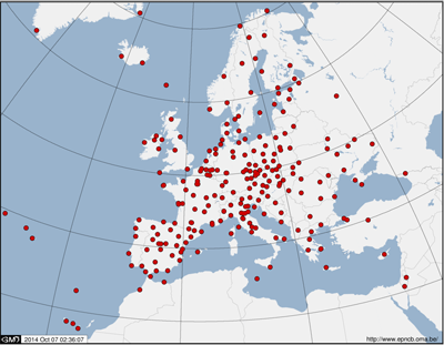
EUREF Permanent Tracking Network
The main mission of the GNSS research group is to include Belgium in international reference frames, such as the global International Terrestrial Reference System (ITRS) and the European Terrestrial Reference System (ETRS89). This integration is done through permanently observing GNSS sites (installed on the Earth’s surface) with well-monitored positions and velocities in the ITRS or ETRS89 systems. These stations are then used as reference points with respect to whom a user can precisely determine his position in an international frame.
This mission comprises the following tasks:
- Installation and maintenance of permanently observing GNSS sites in Belgium
- Integration of these permanent GNSS stations in international observation networks, such as the International GNSS Service (IGS) and the EUREF Permanent Network (EPN) through provision of the data, contribution to the data analysis and, in the case of the EPN, hosting the EPN Central Bureau (www.epncb.oma.be)
- Study and mitigation of GNSS errors which can degrade the precision of the estimated positions and velocities of the reference stations
In addition to its main mission, the GNSS research group also aims at exploiting the permanent GNSS tracking data of the reference stations for several multi-disciplinary scientific studies and services:
- Monitoring of the Earth’s ionosphere for detecting short-term perturbed ionospheric conditions due to space weather events;
- Study of long-term variations of the ionosphere for geophysical research;
- Study and monitoring of the Earth’s troposphere in support of weather prediction services and climatological research;
- Study and monitoring of ground deformations at local, regional and global scale.
All of the above-mentioned applications use GPS signals. Some use in addition GLONASS signals. In addition, our scientists are studying the use of new satellite navigation signals (e.g. new GPS and Galileo signal) to improve these applications.