
Commemoration of the Liège 1983 earthquake
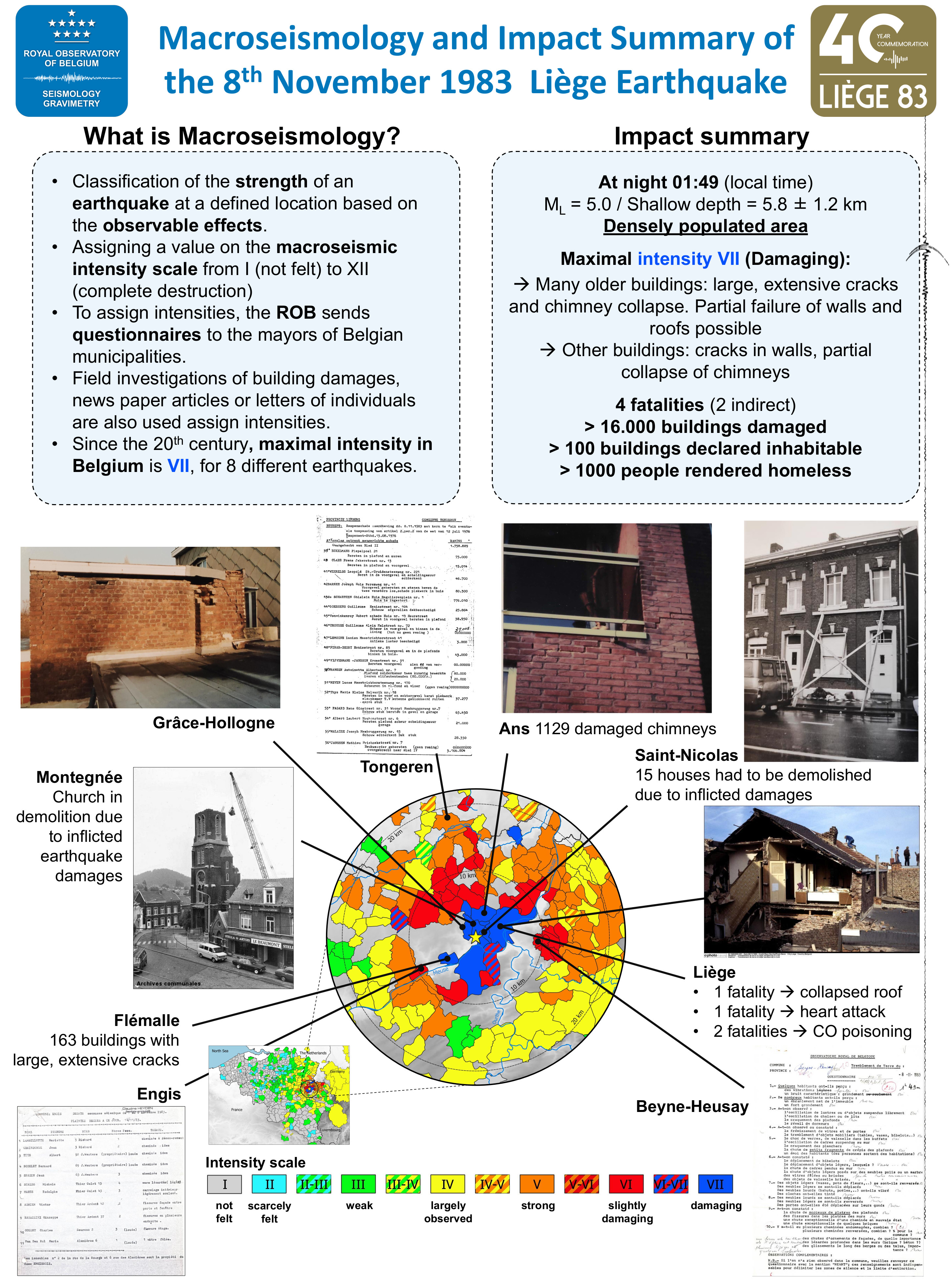
On Wednesday 8 November 1983, 40 years ago, a medium-sized earthquake shook the city of Liège. This earthquake occurred in the middle of the night at 1:49 am local time (0:49 UTC) and had its epicenter in the commune of Saint-Nicolas, a densely populated municipality west of the city of Liège. This is the last earthquake with significant damage in Belgium. The earthquake had a local magnitude of 5.0 and its hypocenter was located at a depth of 5.8 kilometers with an uncertainty of 1.2 kilometers. The earthquake was felt all over the Belgian territory, as far away as Amsterdam (Netherlands) in the north, Frankfurt (Germany) in the east and Metz (France) in the south.
 In Belgium, tectonic earthquakes usually occur at greater depths of 10 to 15 km. Due to its shallow nature, the 1983 Liège earthquake caused severe damage in the communes of Saint-Nicolas, Glain and Montegnée, as well as in the cities of Liege, Seraing, Ans and Grâce-Hollogne. Moreover, ground movements were further amplified by soft Quaternary deposits of the Meuse river and by the underlying folded geological structure. The strength and damage of an earthquake at the surface is expressed by the European EMS98 intensity scale. In the epicenter and in most of the Liège agglomeration, the intensity was the highest, i.e. intensity VII, and caused considerable damage. The impact of the ground motion at the surface is expressed by the European EMS98 intensity value. In the epicenter and in most of the Liège agglomeration, intensity VII was reached, causing damage. Older vulnerable houses experienced severe damage: large cracks across the walls, collapsing chimneys that caused additional damage after their fall and a few buildings even partially collapsed. More recent buildings experienced some cracking of the walls and chimneys were partially damaged. Many houses had already been weakened by subsidence due to mining in the Liège coal basin and due to decades of groundwater fluctuations.
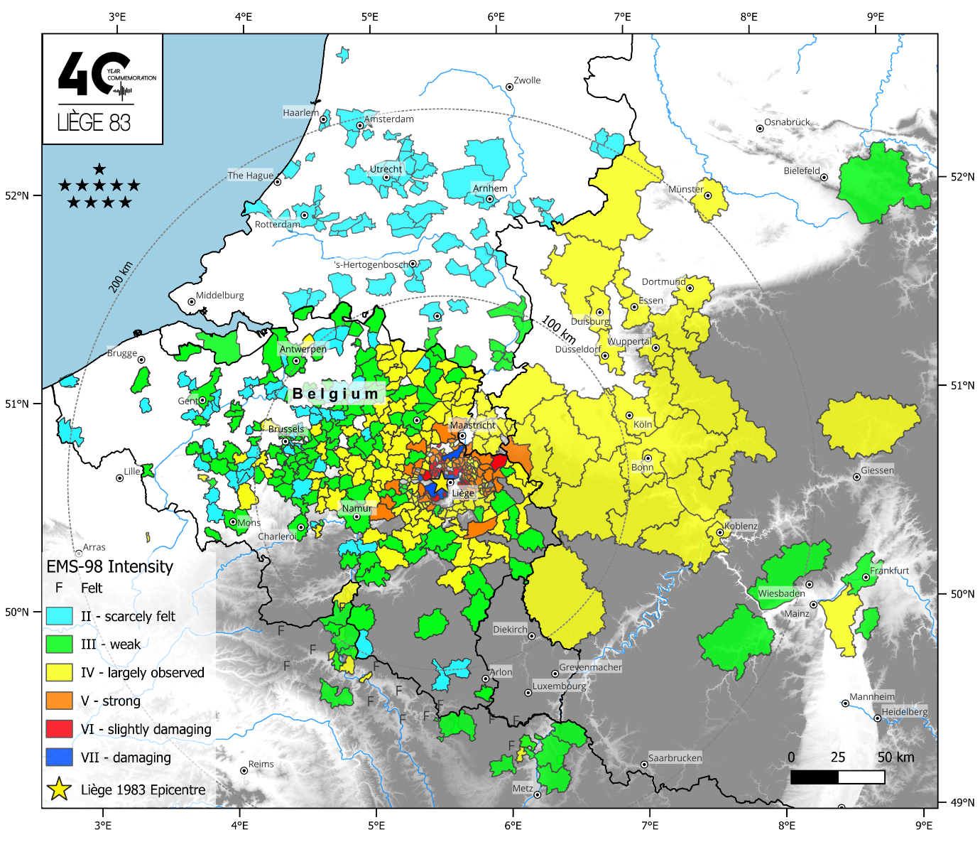
Macroseismic intensity map of the Liège earthquake on 8 November 1983 in Belgium. Maximum intensity was VII.
The Liège earthquake was officially recognised as a natural disaster and, consequently, residents could have the damage to their homes compensated by the National Disaster Calamity. This info is currently kept in the Belgian State Archives and contains at least 16,000 files with detailed descriptions of damage and its reimbursement. In the end, over 100 million euros (adjusted for inflation) was reimbursed. This archive, rare in Western Europe, is a very rich database for assessing the financial impact of a shallow earthquake in urban areas. In the end, more than 100 houses were declared uninhabitable, more than 1,000 people were homeless and, sadly, there were 2 fatalities.
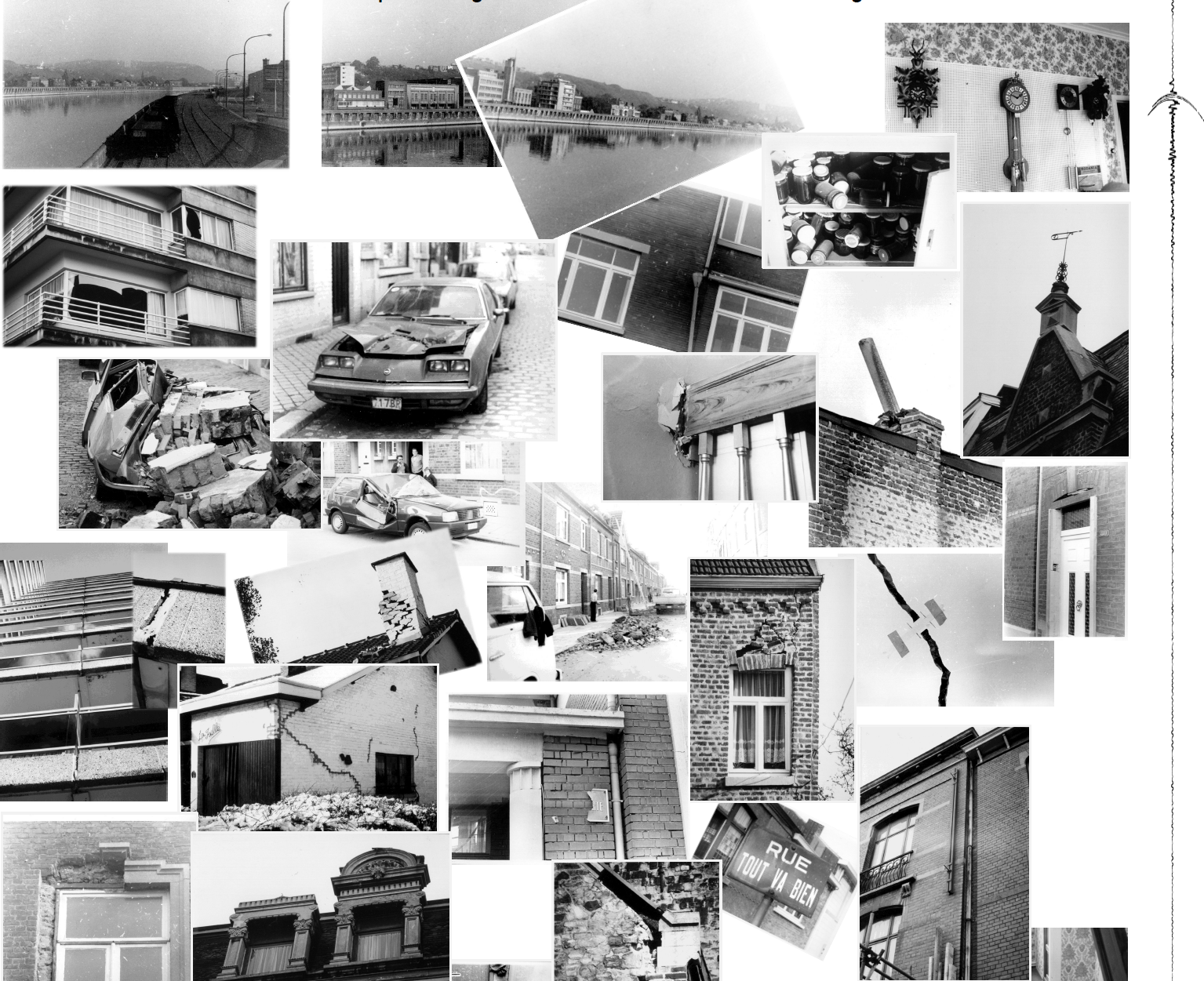
Pictures of damage in the epicentral area around Saint-Nicolas, Flémalle and Liège.
At the time of the 1983 earthquake, the Seismology Department of the Royal Observatory of Belgium only had 4 seismographs operational in Uccle, Dourbes, Membach and Walferdange (Luxembourg). Since seismograms were only available in analogue form and printed on paper, they had to be collected immediately after the earthquake from these seismic stations. Earthquake arrival times from European seismic stations were forwarded to the Observatory by telegram in the days after the earthquake. Calculating magnitude and depth, crucial parameters to calculate the impact of an earthquake, was a slower process at that time, which could take up to hours or even days. The 1983 Liège earthquake was therefore the trigger to install a modern dense seismic network in Belgium. Currently, the Royal Observatory of Belgium operates a network of 29 surface and borehole seismometers and 16 accelerometers, spread over the Belgian territory, which enable seismologists to determine the location, magnitude and depth of an earthquake in minutes.
On Wednesday, 8 November 2023, the 1983 Liège earthquake will be commemorated at the Royal Observatory of Belgium during a scientific study afternoon that will be attended by those in charge of the city of Liège, national and regional crisis centres, federal and regional authorities, geologists, seismologists, and engineers from all universities in Belgium.
Source parameters:
- Epicenter: 50.6280°, 5.5150°
- Local magnitude: 5.0
- Depth of the hypocenter: 5.9 ± 1.2 km
- https://seismologie.be/en/seismology/earthquakes-in-belgium/lv243oom5
Impact summary of the 1983 Liège earthquake presented in a conference poster.