
Science and culture at the Royal Palace 2016
 CARTOGRAPHIAE
As each year, the Royal Palace in Brussels opens its doors to the public in summer: from 22 July to 4 September 2016. The public will be able to discover the exposition Cartographiae showing maps and cartography throughout the centuries.
In order to bring the intriguing and little-known world of cartography closer to the public, the 10 federal scientific institutions of Belgium (including the Royal Observatory of Belgium) have selected a number of representative items from their collections to show the various aspects of this particular field of science: precious cartographic material, thematic maps, cartographic measurement instruments, works of art related to the topic, and much more.
The Royal Observatory provided items related to the project “Carte du Ciel” (see http://www.astro.oma.be/en/scientific-research/astronomy-astrophysics/carte-du-ciel/) and shows also an Ertel theodolite.
For centuries maps have been our window to the world and helped us find our way, on the road, at sea, in the sky and even in the universe…
As true scientific precision tools for particular fields, maps are often precious cultural and social documents, reflecting world views of societies at a given moment. Maps were often used for political and commercial purposes in order to have better control of a given territory. They have become more diversified and have been introduced in new fields.
Modern cartography is of very high precision, thanks to satellite imaging, which allows us to study the dynamics of various phenomena, meteorology and atmospheric sciences, geology, the environment, the history of society, works of art, etc.
Whatever their nature may be, maps allow us to adventure into the different spaces that surround us and to comprehend them. Some maps help us find our way, others help us to measure, calculate, anticipate, etc. And still others just make us marvel and wonder in the face of their beauty or because they fuel our thirst for exploring new spaces and the world.
Furthermore, the visitor can discover the Website Cartesius, the largest and richest cartographic collection for Belgium and Central Africa.
The exposition Cartographiae was initiated by the Federal Science Policy Office and its ten federal scientific institutions (the State Archives, the Royal Library, the Royal Belgian Institute for Space Aeronomy, the Royal Meteorological Institute, the Royal Institute for Cultural Heritage, the Royal Belgian Institute of Natural Sciences, the Royal Museum for Central Africa, the Royal Museums of Art and History, the Royal Museums of Fine Arts of Belgium, the Royal Observatory and the Planetarium), and the National Geographic Institute.
The initiative for this exhibition can be seen in the context of the International Map Year 2015-2016 (http://mapyear.org/), proclaimed by the United Nations to promote cartography by valorizing the art, science and technology related to the development of maps and the impact of geographic information in our everyday society.
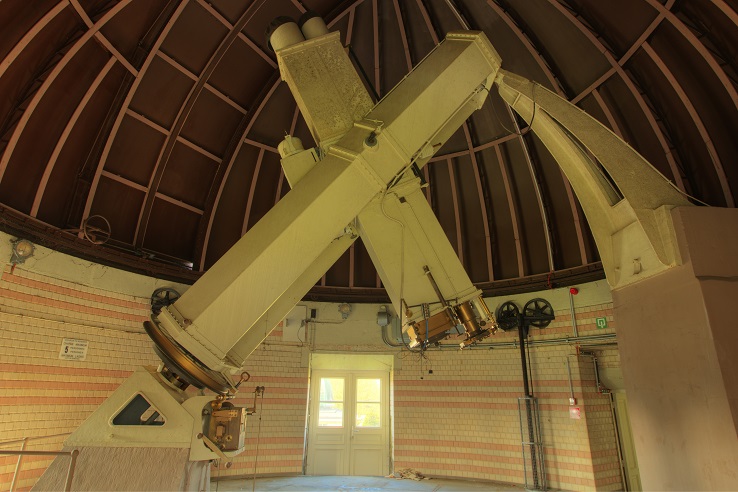
Astrographic equatorial telescope which has contributed since 1908 to the mapping of the Uccle zone for the “Carte du Ciel” project (Photo : P. Van Cauteren).
Practical info
From 22/07/2016 to 04/09/2016
Royal Palace – Place des Palais/Paleizenplein – 1000 Brussels
Opening hours:
From Tuesday to Sunday, from 10.30am to 5.00pm (last entrance : 03.45pm).
Free admission
Security checks are carried out at the entrance. It is highly recommended not to bring any large items (any types of bags and luggage).
Further information
• Website of the exposition Cartographiae (soon online)
• Website of the Royal Palace in Brussels
![]()